Advanced search
Related Searches: Bluetooth, Virtual Reality, android, mtk, smart phone, smart watch, Keyboard, OPENBOX View all
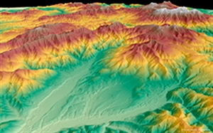
Picture of GEO Elevation Services

GEO Elevation Services

SKU: FS995100
Whether planning an infrastructure network, conducting a military intervention mission in unknown terrains, or analysing terrain features for oil and gas exploration: accurate terrain height information is critical. Precise and reliable elevation data supports a wide range of applications and forms the foundation of any accurate geospatial product. With five core product levels GEO Elevation simplifies access and use of elevation data and provides exactly the right models for all project requirements.
Reproduction is welcome and allowed for free circulation only.
     

Whether planning an infrastructure network, conducting a military intervention mission in unknown terrains, or analysing terrain features for oil and gas exploration: accurate terrain height information is critical.

Precise and reliable elevation data supports a wide range of applications and forms the foundation of any accurate geospatial product.

With five core product levels GEO Elevation simplifies access and use of elevation data and provides exactly the right models for all project requirements.

What You Get
  • Elevation data matched to individual business need: large area coverage for large scale projects vs. high level of accuracy for local coverage
  • Rapid on-demand delivery of high precision elevation data anywhere in the world
  • All products framed to individual Area of Interest with
    optimised pricing per km²
  • Based on spaceborne optical and radar technologies

The scope of delivery can be adapted to individual needs by choosing to add a set of auxiliary layers or corresponding orthorectified images to the input data. Highly developed digital data processing flow line and a large production capacity allow for unique time and cost-efficient production and delivery.

  • Elevation30: unique 3D geographic reference database covering > 80 Mio km²
  • WorldDEM™ is the global elevation dataset of unprecedented quality, accuracy and coverage - available from 2014
  • Elevation8: from stereo and tri-stereo data - for mapping, hydrology and exploration
  • Elevation4 and Elevation1: highly detailed elevation information for local projects.